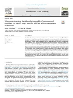
When context matters: Spatial prediction models of environmental conditions can identify target areas for wild bee habitat management interventions
| dc.contributor.author | Sydenham, Markus A.K. | |
| dc.contributor.author | Moe, Stein Ragnar | |
| dc.contributor.author | Eldegard, Katrine | |
| dc.date.accessioned | 2019-10-08T10:54:59Z | |
| dc.date.available | 2019-10-08T10:54:59Z | |
| dc.date.issued | 2019 | |
| dc.identifier.issn | 0169-2046 | |
| dc.identifier.uri | http://hdl.handle.net/11250/2620872 | |
| dc.description.abstract | Prioritizing where to implement management interventions is critical because managers have limited Budgets and the effect of habitat enhancement depends on site-specific environmental conditions. Field experiments can identify the conditions where habitat enhancement is most effective, but are typically of limited extent and thus not sufficient for producing spatial predictions that can guide management efforts. We tested if we could produce spatial predictions maps – showing where management interventions to enhance bee habitat would be most successful – by combining spatial predictions of plant community composition (i.e., environmental conditions) obtained from field surveys with a field experiment, in which we quantified the effect of three types of management interventions on bee species richness. Using information from digital maps, we predicted plant species composition within power line clearings across southeast Norway. The intervention type, which involved cutting and removal of the woody vegetation, resulted in the largest increase in bee species richness, but the enhanced bee species richness was limited to clearings with forb-dominated vegetation. Importantly, the estimated effects on bee species richness did not differ between models using the predicted, versus the empirically observed, plant species composition as predictor, making it possible to produce spatial predictions of the increase in bee richness from implementing different management interventions. Synthesis and applications: Combining field surveys With data from field experiments can be used to produce high-resolution maps showing where wild bee habitat enhancement is likely to have the greatest effect. Such maps can inform decisions about where to allocate costly management interventions. | nb_NO |
| dc.language.iso | eng | nb_NO |
| dc.rights | Navngivelse 4.0 Internasjonal | * |
| dc.rights.uri | http://creativecommons.org/licenses/by/4.0/deed.no | * |
| dc.subject | Habitat management | nb_NO |
| dc.subject | Habitat restoration | nb_NO |
| dc.subject | Spatial predictions | nb_NO |
| dc.subject | Targeted management | nb_NO |
| dc.subject | Bees | nb_NO |
| dc.title | When context matters: Spatial prediction models of environmental conditions can identify target areas for wild bee habitat management interventions | nb_NO |
| dc.type | Peer reviewed | nb_NO |
| dc.type | Journal article | |
| dc.description.version | publishedVersion | nb_NO |
| dc.rights.holder | © 2019 The Authors. | nb_NO |
| dc.subject.nsi | VDP::Matematikk og Naturvitenskap: 400::Zoologiske og botaniske fag: 480 | nb_NO |
| dc.source.volume | 193 | nb_NO |
| dc.source.journal | Landscape and Urban Planning | nb_NO |
| dc.identifier.doi | 10.1016/j.landurbplan.2019.103673 | |
| dc.identifier.cristin | 1734753 |
Tilhørende fil(er)
Denne innførselen finnes i følgende samling(er)
-
Scientific publications [1392]
Vitenskapelige artikler, kapitler og monografier i Open Access.

Med mindre annet er angitt, så er denne innførselen lisensiert som Navngivelse 4.0 Internasjonal